Edgewater Dr. Bridge information (Port Charlotte area)

Bridges along Edgewater Drive in Port Charlotte, FL

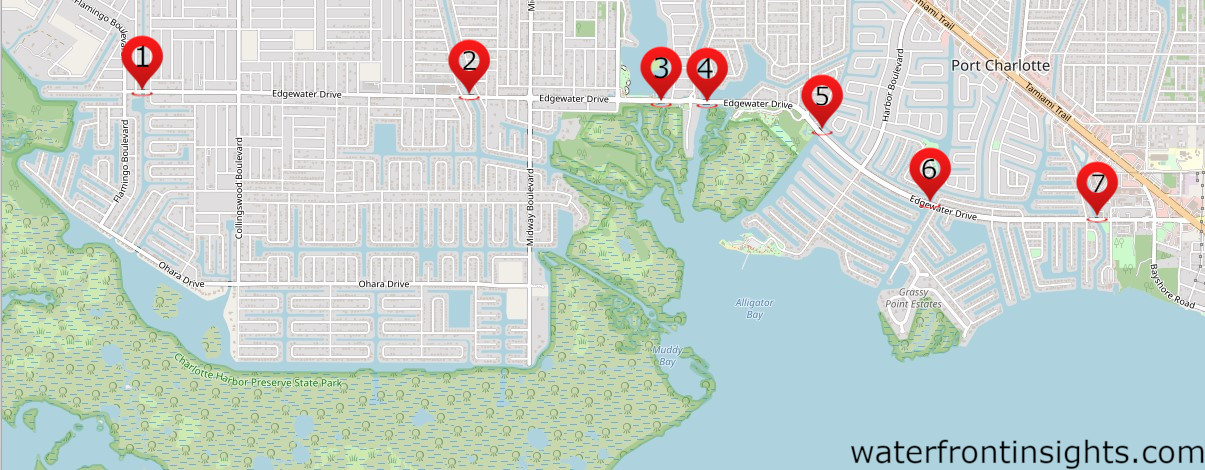
    Click on bridge for more information

    Marker BridgeBoat ClearanceGPS
    1Edgewater Dr. over COMO WATERWAY26°58’27” N, 82°09’51” W
    2Edgewater Dr. over PELLAM WATERWAY26°58’25” N, 82°08’10” W
    3Edgewater Dr. over West Springlake Waterway26°58’24” N, 82°07’12” W
    4Edgewater Dr. over East Springlake Waterway26°58’24” N, 82°06’57” W
    5Edgewater Dr. over SUNRISE WATERWAY26°58’16” N, 82°06’23” W
    6Edgewater Dr. over ELKCAM WATERWAY10ft26°57’56” N, 82°05’49” W
    7Edgewater over OLMAN WATERWAY
    26°57’52” N, 82°04’57” W

    Punta Gorda Isles canal system | Tarpon Inlet | Part 2

    PGI, Part 2

    Hello, and welcome back to another video brought to you by Chris Mann! This is the second in our series showcasing a real time boat ride down Tarpon Inlet, located in Punta Gorda Isles (PGI). In this video we show you the Tarpon Inlet from the Marion Ave. Bridge south to Yellow Tail Lagoon and Sandfish Cove. We’ll talk about water depths, bridge clearances, and other issues important to local boaters.

    References:

    Punta Gorda “BOATS, DOCKS, AND WATERWAYS” http://www.ci.punta-gorda.fl.us/home/…

    ISLES YACHT CLUB: islesyc.comfishville.com/marina Laishley Park Municipal Marina laishleymarina.com

    US Coast Guard Marin Sanitation Devices: https://www.dco.uscg.mil/Our-Organiza…

    Pompano Inlet | PGI | Punta Gorda, Florida

    A brief look at part of the Punta Gorda Isles (PGI) canal system in Charlotte Harbor. In this video we focus on Pompano Inlet. Pompano inlet is a deep channel connecting several of the central PGI canals (listed below) to the Peace River, and Charlotte Harbor. It’s also the passage used to get in and out of the PGI Yacht Club located at the end of Marlin Cove. Pompano Inlet is the passage to get to the following canals in PGI.

    Sailboat water canals:

    Sheepshead Bay

    Porpoise Cove

    Bass Bay

    Snook Bayou

    Turtle Bay

    Dolphin Inlet

    Grouper Cove

    Marlin Cove

    Bonita bay

    Northern part of Sailfish Estuary

    Small powerboat, Non-sailboat water (restricted by W. Marlon Ave Bridge)

    Barracuda Bayou

    Shark Cove

    Sailfish Estuary

    Cero Bay

    Mackerel Lagoon

    Redfish Inlet

    Swordfish Strait

    Yellowtail Cove

    Starfish Lagoon

    Snapper Strait

    Ladeyfish Bay

    Angelfish Cove

    Catfish Bayou

    Devilfish Bay

    Dogfish Inlet

    Moonfish Lagoon

    Lister Waterway | Buena Vista Area Waterway | Port Charlotte Florida

    In this video, we take you on a short tour showcasing Lister Waterway in Port Charlotte FL. Lister Waterway is part of the Buena Vista waterway system and is in what some refer to as the “old sailboat section” of Port Charlotte. It is located just north of the Peace River, and directly across from Fisherman’s Village in Punta Gorda. We include canal depths and other general waterway information reverential to boaters and those interested in waterfront living.